The fuel stop in La Ceiba forced a vertical climb to 10,000' in order to clear the mountains, and go on course. Then it was on up to 11,000', my assigned altitude from the center controller (Toncontin). It would have been expiditios to do a slow climb from Roatan, and be at cruising altitude before getting to La Ceiba. C'est la vie.
 This section of the flight was over dense clouds, but there were large holes over the valleys, displaying plenty of emergency fields to land in. Once again I was comfortable, flying so high and having many options in case of engine problems.
 You can see that Honduras is very mountainous, but landing areas abound (for an aircraft that weighs 700lbs, lands at 40kts, and only needs 400 feet).
 Back over a fairly solid cloud deck.
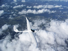
Another great feature of the Lambada is the ability to descend at slow speed with the spoilers out, giving a steep descent angle. We can descend through small holes that a faster aircraft is not able to negotiate.
 There were 3 airfields shown on the map in this area. Many of the fields have the notation "Not Useable" which pertains to the drug war and the bulldozing of airstrips by the government in a failed attempt to halt drug trafficing. All it halted was the elimination of general aviation.
 The large city of Tegucigalpa.
 You can see the yellow highlighted route. Click on the photo to enlarge.
 Pacific Ocean! This is my second coast to coast flight in a Lambada.
 Soon after entering Nicaraguan airspace, the smoking volcano named San Cristobal loomed off my starboard wing 10 miles off the designated airway. I called Managua Center and requested permission to take a closer look and take some pictures, and he said "sure". (Well, that's not the exact wording). So I descended to 8,000' to take a good look.
 This has to be the most awesome volcano I have ever flown over.

 Nicaragua is full of volcanos.
 Crossing Lago de Managua
 And then across Lago de Nicaragua
 I love taking these sparkling wing photos.
 After crossing into Costa Rica, the landscape changed abruptly from brown and mountainous to green rolling hills with lower, more rounded mountains.
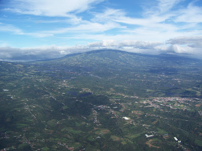 Approaching San Jose, Costa Rica.
 There were 3 airfields shown on the map in this area. Many of the fields have the notation "Not Useable" which pertains to the drug war and the bulldozing of airstrips by the government in a failed attempt to halt drug trafficing. All it halted was the elimination of general aviation.
 The large city of Tegucigalpa.
 You can see the yellow highlighted route. Click on the photo to enlarge.
 Pacific Ocean! This is my second coast to coast flight in a Lambada.
 Soon after entering Nicaraguan airspace, the smoking volcano named San Cristobal loomed off my starboard wing 10 miles off the designated airway. I called Managua Center and requested permission to take a closer look and take some pictures, and he said "sure". (Well, that's not the exact wording). So I descended to 8,000' to take a good look.
 This has to be the most awesome volcano I have ever flown over.
 Nicaragua is full of volcanos.
 Crossing Lago de Managua
 And then across Lago de Nicaragua
 I love taking these sparkling wing photos.
 After crossing into Costa Rica, the landscape changed abruptly from brown and mountainous to green rolling hills with lower, more rounded mountains.
 Approaching San Jose, Costa Rica.
La Ceiba to San Jose took 4.5hrs to cross 450nm of the most varied, awesome terrain I have ever crossed in one flight. The whole trip was one to treasure always, and I am grateful to new owner David Stewart for letting me bring his Lambada to him. He is sure to have many adventures in his beautiful country in the Lambada.
The entire trip from Melbourne to San Jose took 13.7hrs and covered 1387nm. The Lambada burned a total of 52 gallons of 93octane unleaded automotive fuel (mogas) and 100LL.
An around the world flight looks more possible all the time. After all, it is only 20 of these flights strung together!